
Christophe Morhange (CEREGE)
Emmanuel Gandouin (IMBE)
This project aims at elaborating an interpretation of palaeo-environmental data of a poorly studied region from a geoarchaeological point of view – the Danube delta. The project combines bio-sedimentological analyses, geophysics, geochemistry, aerial photography and GIS mapping with classical archaeology, a first interdisciplinary approach in Romania. This project investigates an ancient harbour through this interdisciplinary method to create a new work model specific to the Danube delta’s milieu, that can be applied to other important archaeological sites from this area, such as Orgamé/Argamum, Enisala, Halmyris etc. This project integrates sedimentary archives from fluvial and coastal areas in the archaeological context.
The main results were obtained from the fluvial site of Noviodunum, located on the right bank of the Danube in vicinity of modern-day Isaccea. Chrono-stratigraphic data was obtained, allowing us some conclusions about the river dynamics at Noviodunum and about the possible location of the ports:
- The upstream cores show that until the 13th century AD, a secondary canal flowed west of the city.
- They also contain a sequence that corresponds to a port facies. According to the age-depth model, the port facies appears in the 1st century AD, corresponding to the installation of the imperial fleet at Noviodunum.
- Downstream, we discovered a Byzantine-Medieval (post 7th c. AD) harbour basin. Its existence was also confirmed through archaeological excavations, confirming the historical theory of an existing harbour and a squadron of the Byzantine fleet in Noviodunum.
- The extent of the harbours basins is yet unknown. Their position is integrated in the communication network and the defensive system of the fortress.
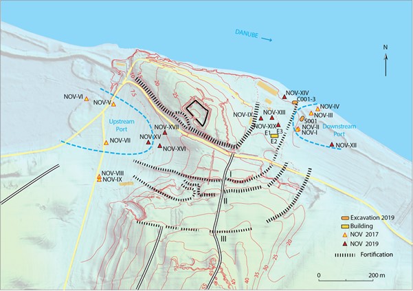
Harbours position in the urban fabric. With blue dashed line, the possible extension of the basins; the three earth ramparts, in black dotted line; the routes (A-C) identified on aerial photos by Ștefan (1973), in white lines with black contour. In black line, the Turkish fortress (Credit: P. Pentsch)