
Mathilde HERVE (OT-Med PhD student)
Cécile ALBERT, Alberte BONDEAU, Thierry TATONI (IMBE)
Claude NAPOLEONE (INRA)
The overall objective of the project is to design alternative prospective scenarios for landscape management accounting for both land-use and farming innovative practices that would allow the conciliation of regional targets in terms of socio-economic development and biodiversity conservation under global change constraints. These scenarios will test the effect of European agro-environmental policies (e.g. CAP) on the regional and sub-regional scale. They will be derived from participative approaches, thus accounting for local stakeholders’ knowledge of the region and integrating a diversity of representations and visions. Combining both top-down and bottom-up approaches, our scenarios will finally provide useful biodiversity-oriented decision tools to inform public policies for biodiversity conservation at regional scale.
- Recommendations formulated to develop biodiversity scenarios at different scales and to co-construct scenarios with stakeholders at local scale
- Downscaled scenarios of land use and land cover change for the Provence Alpes Côte d’Azur region
- Method developed to use these scenarios in order to look at changes in connectivity (connectedness) for representative species from the region
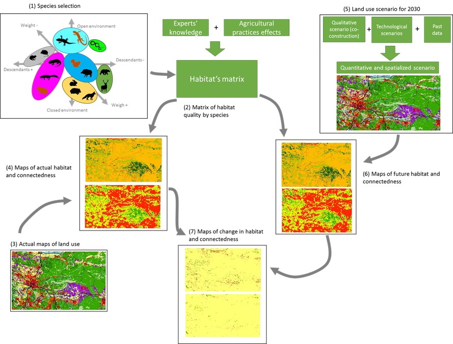
m=Methodology developed in the SIMBIOSE project to identify land use change impact on habitats and connectedness.
(1) species selection based on functional groups; (2) definition of habitat quality matrix using expert knowledge and information on agricultural impacts based on a literature review; use of this matrix to convert actual land use maps (3) into habitat and connectedness maps (4); (5) Modelling of future land use (2030) using qualitative information from workshops with stakeholders, existing scenarios and past data (ex. urbanization, population dynamic…); Using the habitat quality matrix, the future land use is converted into maps of habitats and connectedness (6).
Actual and future maps are compared to calculate the change in habitats and connectedness for each chosen species.