Pierre Dias (Task DIGUE 2020) & Eugénie Pérouse (Task SEISMIC) (OT-Med post-docs)
Raquel Bertoldo, Alexandra Lindenman, Séverin Guignard (ESPACE)
Lucilla Benedetti, Lionel Siame, Olivier Bellier (CEREGE)
Hubert Mazurek (LPED)
Ante Ivcevic (Doctorant doc2amu)
With contribution by : Abdelkhalak Ben Moussa & Kamal Aggharoud (Faculté de Tétouan), Stéphane Bonelli (IRSTEA), Annick Tekatlian (Cerema), Christoph Chevalier (IFSTTAR), Thibault Mallet (Symadrem)
Considering the long history of human occupation and risk management in the Mediterranean regions, the RISKMED project is interested in proposing a common framework to discuss shared issues around the management, mitigation and adaptation to different types of natural risks faced by Mediterranean communities – i.e. earthquakes, marine submersions, landslides, erosion, floods, etc. through four tasks (T).
T1) This task deals with developping a common reflection around risk as social knowledge, central to risk management and adaptation in Mediterranean regions.
T2) Task DIGUE2020 : this task deals with mitigation and perception of marine submersion in the PACA region. This study focuses on risk perception and
1) Expert versus vernacular knowledge;
2) Trust in risk management;
3) Time frames: memory and future projections at 2 sites (Port-Saint-Louis-du-Rhône and Fréjus)
T3) Task SEISMIC: this task deals with seismic hazards characterisation and mitigation. This study focuses on 2 regions in central Italy and in western Turkey that have experienced catastrophic earthquakes less than 10 years ago for Italy, but more than 50 years ago, for western Turkey. The objectives are twofold:
1) to improve our understanding on the slip-size, frequency and dynamics of the earthquakes in the Mediterranean area and better characterize the seismic hazard that derives from fault ruptures.
2) to design a methodology to build relevant information on seismic risk, based on the state- of-the-art scientific knowledge on seismic hazard, local knowledge and people’s perception of this risk.
T4) Task MOROCCO : this taks deals with a reassessment of natural hazards parameters (mainly seismic) along the southern front of the Rif (Meknes-Fes area) and indicators of natural risks’ perception in Northern Morocco.
Preliminary results for the Task MOROCCO suggest that:
- There is a discrepancy between local authorities’ message and researchers’ position.
- Local inhabitants are not aware of the seismic risk, unless they remember a big event (e.g. in Al Hoceima province, or flooding risk by wadi Martil).
- Construction occurs in non-authorised areas due to lack of control or financial pressure.
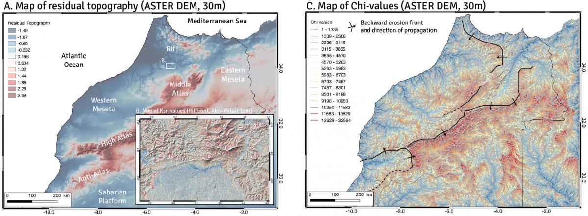
Multi-scalar analysis of digital topography datasets (ASTER and Alos-Palsar) over Morocco allows deriving geomorphic metrics such as residual topography (a proxy to locate prominent relief), Ksn (a proxy to locate active uplift), Chi (a proxy to map steady-state or not topography).
Preliminary results for DIGUE 2020 task :
The information channel on which people rely is important (personal experiences, transmitted knowledge, official information, etc.).
The type of information people use and the level of trust they have in public authorities’ management are linked, i.e.:
- Trust in personal experience and technical/scientific sources corresponds to a defiance towards public actors deemed to be a hindrance to technical and scientific advances.
- Trust in the intentions of public actors corresponds to a mistrust of the technical and scientific aspects that can be considered as constraints for effective management.
- eople who think they have no particular knowledge, neither by experience or by technical and/or scientific sources, trust both the intentions and capabilities of public actors.
- All individuals have a low sense of vulnerability and trust risk management