Daniel Contreras (OT-Med post-doc)
A. Kirman, S. Thoron (GREQAM)
J. Guiot, C. Morhange (CEREGE)
A. Bondeau, W. Cramer (IMBE)
D. Isoardi, L. Bernard (CCJ, MMSH)
Other collaboration : Sander van der Leeuw (School of Human Evolution and Social Change, Arizona), Rob Axtell (George Mason University, Fairfax, Virginia, USA), Sylvain Olivier (Univ Nimes)
This Project investigates human-environment interactions in the Mediterranean past, using agent-based modeling to examine the limits of cultural adaptability in dynamic environments. Drawing together interdisciplinary contributions to the modeling of climate, agroecosystem, and social systems, it examines how major climatic shifts throughout the Holocene might have affected the inhabitants of the Mediterranean Basin, focusing particularly on identifying the key determinants of vulnerability and resilience.
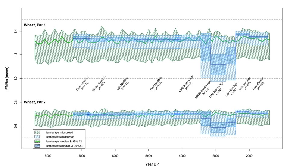
We have integrated two tools, i.e. agro-ecosystem modeling of potential agricultural yields and spatial analysis of archaeological settlement pattern data, in order to examine the human consequences of past climatic changes. We have focused on a case study in Provence (France). We have calibrated this model for past crops and agricultural practices and from paleoclimate data, we have estimated realistic potential agricultural yields under past climatic conditions. These serve as the basis for spatial analysis of archaeological settlement patterns, in which we examine the changing relationship over time between agricultural productivity and settlement location. Our results suggest that settlement patterns were closely tied to agrosystem productivity throughout most of the Holocene, with the notable exception of the period from the Middle Bronze Age through the Early Iron Age (3500 to 2500 years BP). We concluded that vulnerability and resilience to climate change may be strongly dependent on societal variables, when political or cultural factors become dominant.

Potential cereal productivity of the landscape (i.e. all the pixels of the considered region), in green, and of the exploited fraction (i.e. the pixels really occupied), in blue; shaded areas are the midspreads, and the more darkly shaded areas the 95% confidence intervals around the medians. The upper register is W1 (high agricultural intensity wheat) and the lower register, plotted on the same y-axis, is W2 (low agricultural intensity wheat). On most of the Holocene, the sites occupied by settlement were those with higher productivity.


