
Matteo Vacchi (OT-Med post-doc)
Christophe Morhange (CEREGE)
Global sea-level rise is the result of an increase in the ocean volume, which evolves from changes in ocean mass due to melting of continental glaciers and ice sheets, and expansion of ocean water as it warms. The elevation of ocean surface relatively to the ocean floor is defined as a ’relative sea level’ (RSL), and any shift on height of either of these two surfaces produces a RSL change. RSL varies due to a variety of processes, acting at different time scales. In the long term these factors are eustatic, deformation of the solid earth and tectonic. Our understanding of current rates of sea-level rise from tide gauge and satellite data, and of the ongoing mass loss from the major ice sheets requires correction for glacial isostatic adjustment (GIA) effects that are both calibrated to, and independently tested by, observations of former sea levels.
The MEDMAX project aims at creating a database of Holocene (last 10 ka) geological data across the Mediterranean basin. This represents a tool of fundamental importance for understanding and tuning GIA models and to assess sea level rise hazards, which are particularly magnified in low-lying or subsiding coastal areas. In the Mediterranean, different kinds of RSL markers have been used to reconstruct RSLs: biological, sedimentological, geomorphological and archaeological. The production of such great amount of literature, which is still rapidly growing in number, has led to the obvious consequence of fragmented information, only occasionally reviewed in some localities, but never collected into an organic database to be analysed at the scale of the Mediterranean basin.
In the framework of the MedMax project, we completed the review of 909 radiocarbon dated Relative Sea-Level (RSL) data-points along the western Mediterranean coast. It resulted in the first quality-controlled database constraining the Holocene sea-level histories along the Spanish, French, Italian, Slovenian, Croatian, Maltese and Tunisian coasts. We reviewed and standardized the RSL data-points using a new multi-proxy methodology that is now the “state of art” for RSL reconstruction in the Mediterranean area. Our relative sea level reconstructions were used to improve the prediction potential of different geophysical isostatic models. All the data-points of the database are freely downloadable in webGIS environment. http://medmax.otmed.fr/
Our results show that current sea level rising rates (1.2 mm/y) are up to three times faster than those recorded in the last 4000 years (0.25 to 0.45 mm/y).
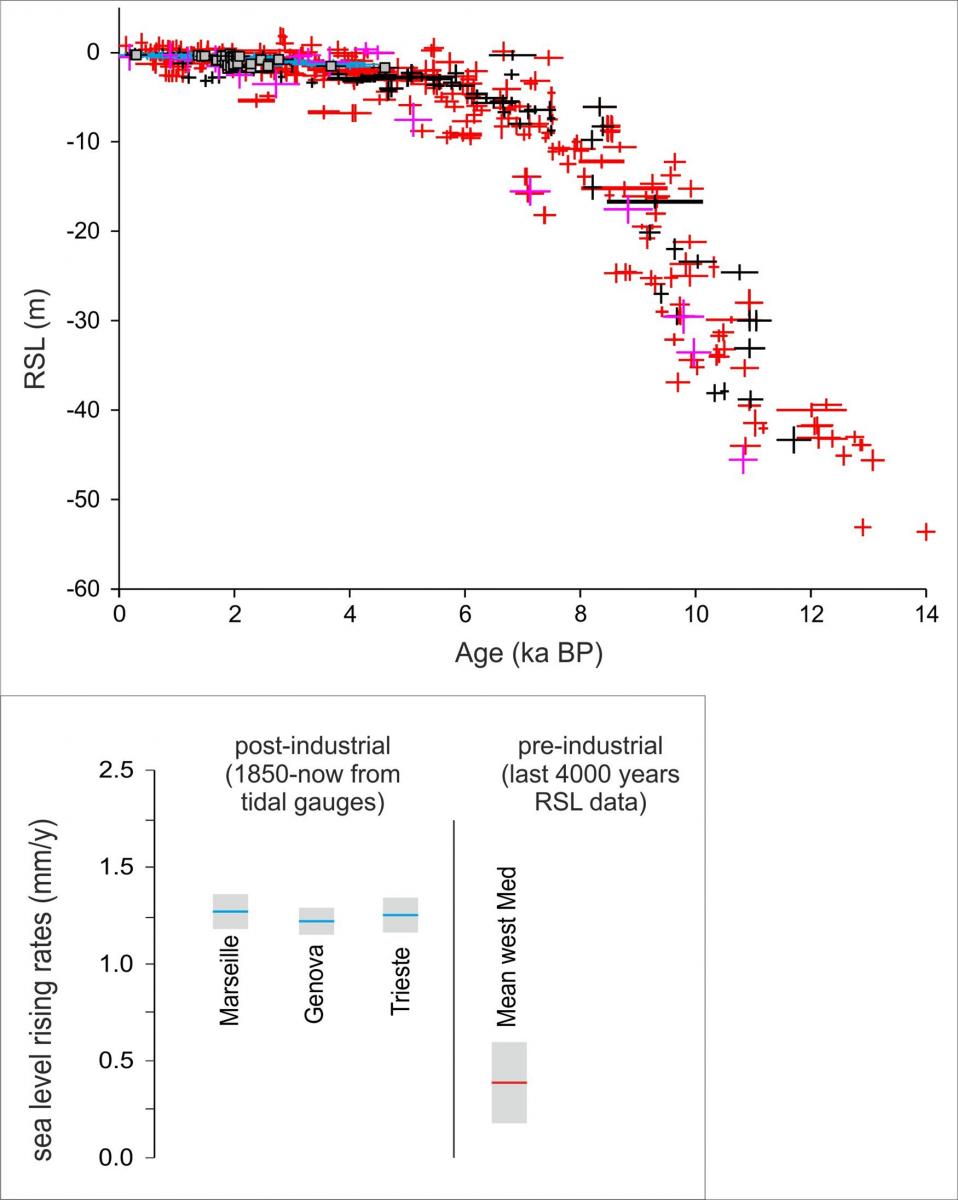
The top figure indicates the evolution of the sea level in the Mediterranean in the last 12000 years.
The bottom figure indicates the postindustrial sea level rise acceleration we can observe by comparing the RSL reconstruction of the last 4000 years with the long tidal gauges available in the Mediterranean