
Laurent PEYRAS, Michel VENNETIER (IRSTEA)
Ginette SARACCO (CEREGE)
Benjamin Mary (PhD OT-Med)
Woody vegetation from earth dikes or dams may promote mechanisms of deterioration such as erosion. The definition of the geometrical roots systems structure, the position into the embankment (depth, extension), as well as the soils conditions where roots grow are essential to anticipate consequences on the hydraulic structure’s safety.
Geophysical non-destructive methods are developped in this project to explore, detect and describe the soil by tomography 3D.
Laboratory experiments have determined intrinsic acoustical and electrical roots’ properties leading to the identification of relevant signatures to discriminate anomalies related to roots in the field. We developed adapted experimental devices to assess different kinds of parameters (roots mass, water content) under controlled conditions. Experiments in semi-controlled conditions, using trees implanted in a homogeneous loam soil, tested the use of temporal induced polarization in complex resistivity tomography or the geometry of sensors for acoustical tomography. Data was processed via innovative processing such as wavelet analysis to exploit the richness of recordings, and results were validated by the determination of real roots position. Despite some limits, the electrical resistivity tomography method was shown to offer an adequate correlation with the location of anomalies due to roots.
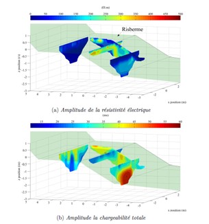
Gauche : Positionnement des plans 2D sous une représentation 3D vue transverse à la digue ; les échelles de couleurs sont dépendantes ; le point rouge indique la position de l’arbre
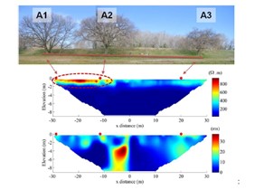
Droite : Section n°1 inversée ; espacement inter-électrodes =1m; profil de 64m réalisé en Wenner-Schlumberger. Les points rouges représentent la position des arbres sur le profil. En haut : amplitude de la résistivité électrique/ En bas : amplitude de la chargeabilité totale